STNP2036: SAHAM TONEY'S NEIGHBOURHOOD PLAN ("MADE" 15-NOV-2021)
  • Home
    • Welcome Message
    • About us & Contacts
    • What's it all about? >
      • Q&A
      • Why Have a Neighbourhood Plan
    • What Do You Think of This Website?
    • Data Protection & OS License
    • Files For Printing
  • Aims
    • Sustainable & Balanced Development
  • Timeline
  • Village Info
    • Saham Toney in Numbers
    • Village Heritage >
      • How Saham Has Been Shaped Through History
      • Saham Toney Heritage Group
    • Planning Issues in Saham Toney
    • Parish Action Points
    • Village quiz
  • SEA & HRA
    • SEA & HRA Screenings
    • Draft Reg 14 Plan for HRA and SEA
    • Draft Reg 15 Plan for HRA and SEA
  • Flood Risk
    • Village Flood Event Photos & Videos
    • Flood Risk Guides
  • Consultations
    • Regulation 16 Consultation on the Plan
    • Regulation 15 Submission of the Plan
    • Regulation 14 (3) Consultation June 2020 >
      • 2020 Reg. 14 Consultation Results
      • Regulation 14 (3) Consultation Documents
      • Reg 14 (3) Consultation Announcement June 2020
      • Online Consultation 'drop-in' sessions
    • SEA Consultation June-July 2020
    • Regulation 14 Consultation 2019 >
      • 2018 Regulation 14 Consultation Results
    • What You Told Us Earlier
    • Awareness & Housing Questionnaire
  • Site Allocations
    • Site Selection Process
    • AECOM Site Assessment Report
    • Site Selection Report
    • Site Allocations Event 14 July 2019
    • Site Allocations Background
    • Master Planning Information
  • Funding & Costs
  • OUR CONSULTANTS
  • Referendum
    • Our Referendum Campaign >
      • "Vote Yes!" Campaign Videos
  • Examination
    • Examination Documents >
      • Summary of the examination results
      • Public Hearing 17 February 2021
  • Publicity
    • Plan Information Leaflet & Pamphlet June 2020
    • Radio Norfolk Interview 6 Nov 2021
    • Saham Saga Articles
    • Stay at Home Slideshows May 2020
    • Village Presentation 7th December 2018
    • Village Presentation 14th August 2018
    • Village Presentation 14 December 2017
    • Parliamentary Debate on Neighbourhood Planning
    • Parliamentary Debate on 5 Year Land Supply
  • Planning Applications
    • Guidelines for Commenting on Planning Applications >
      • How to Seach Breckland Council's Site for Planning Applications
      • Relevant Policies That May Apply to an Application
  • Reg's & References
    • Guides on Neighbourhood Planning
    • Stages of a Plan
  • Archive
    • Archived Reg 14 & 15 Documents >
      • Regulation 15 Submission Documents
      • Reg 15 Policies & Policy Maps
      • Reg 14 (3) Policies & Policy Maps
      • 2019 Regulation 14 Consultation Documents
      • Policy Maps REG 14 (2) Aug 2020
      • Reg 15 Policies & Policy Maps
Picture
NOTE! THIS INFORMATION IS RETAINED FOR RECORD PURPOSES BUT IS NOT THE MOST UP TO DATE, AS IT HAS BEEN SUPERSEDED BY THE REGULATION 15 SUBMISSION, THE DOCUMENTS FOR WHICH ARE AVAILABLE HERE
Below you can find the individual policies from the June 2020 version of the Plan.
These are the most important part of the the Plan as they tell developers, Breckland planners, and anyone else wanting to build in Saham Toney the rules they must adhere to.
You can find the supporting text for each policy in the full version of the Plan HERE
At the foot of the page you will find all of the Policy maps. The numbers of each file represent the policy numbers each map relates to

​​
​Please note: In these extracts bullet points are numbered; in the Plan itself they are lettered - this is just a quirk of the features of "Weebly" which we use to make this website.
Click the + sign on the right to open any of the boxes


The Plan aims to balance the 'privilege' it grants developers to build housing in Saham, with an obligation on them to help preserve and enhance the local environment. Thus there are two main policy groups, as listed below

GROWTH & DEVELOPMENT POLICIES
ENVIRONMENTAL PROTECTION POLICIES
POLICY 1: SERVICES, FACILITIES & INFRASTRUCTURE
​P1.1 For development proposals to be supported, it must be demonstrated that there is sufficient social infrastructure capacity (including education, community facilities, healthcare, public transport, shops, businesses, employment, leisure and open space) available to support and meet all the necessary requirements arising from the proposal.
P1.2 In assessing this capacity, consideration must be given to how accessible social infrastructure is with a preference given to sustainable modes of transport (i.e. walking, cycling and public transport) over non-sustainable driving routes.
P1.3 Development shall take all opportunities to add to and enhance electric vehicle infrastructure.
P1.4 Development shall be appropriately phased to allow delivery of any necessary infrastructure improvements. 
POLICY 2A: RESIDENTIAL HOUSING ALLOCATION
​P2A.1 This Plan provides for 70 new homes up to 2036 through the allocation of sites, with an indicative delivery as follows (number of dwellings per site shown in brackets):
  1. Years 1 to 5: STNP2 (4), STNP9 (3) and STNP16 (12);
  2. Years 6 to 9: STNP1 (10) and STNP4 (17);
  3. Years 10 to 13: STNP7 (8) and STNP13 (5);
  4. Years 14 to 17: STNP14 (5) and STNP15 (6).
P2A.2 Nine sites are allocated in this Plan (through Policies 2H to 2P) for residential development; located as shown on Policy Map 2A.
POLICY 2B: RESIDENTIAL DEVELOPMENT WITHIN THE SETTLEMENT BOUNDARY
​P2B.1 Within the settlement boundary, sensitively designed residential development of a scale consistent with the Neighbourhood Area's place within the Breckland settlement hierarchy will in principle be supported where:
  1. It is in an area of low landscape sensitivity, or where it is in an area of medium or high landscape sensitivity measures are implemented to mitigate harm to the landscape, as set out in Policy 7A;
  2. The scheme does not detract from the character and appearance of the immediately surrounding area and has a density that complies with the guidelines set out in Policy 3B; and
In respect to infill development; proposals do not have the potential for loss of amenity of neighbouring properties; through loss of privacy, overshadowing, loss of daylight, visual intrusion by a building or structure, loss of car parking, loss of mature vegetation or landscape screening and excessive additional traffic resulting from the development.
POLICY 2C: RESIDENTIAL DEVELOPMENT OUTSIDE THE SETTLEMENT BOUNDARY
​P2C.1 Outside, but immediately adjacent to the settlement boundary (as defined in the Local Plan), in addition to the allocated sites listed in Policy 2A, residential development will be restricted to:
  1. Small scale affordable housing on rural exception sites, for people with a Saham Toney connection, as defined by Policy 2D; where the proposed dwellings are consistent with identified needs;
  2. Other types of residential development that need to be located in the countryside (e.g. essential housing for a rural worker), or are otherwise appropriate in countryside locations.
P2C.2 In exceptional circumstances, where it becomes evident the policies in the Neighbourhood Plan are failing to satisfactorily deliver the housing target set in Policy HOU 04 of the Local Plan, other residential development proposals will be considered immediately adjacent to the settlement boundary where these adhere to all relevant policies of the Development Plan.
P2C.3 Should exceptional circumstances apply as set out in P2C.2, proposals for the development of brownfield sites on land outside but immediately adjoining the settlement boundary will be looked on favourably in preference to otherwise equivalent greenfield sites, where development will improve the visual appearance of the site and where the proposal includes measures to remove any form of public nuisance arising or that previously arose from the pre-existing use of the site. 
policy 2D: AFFORDABLE HOUSING
​P2D.1 Where a need for affordable housing is triggered by Local Plan Policy HOU 07, a local connection criterion will be applied for Site Allocations STNP4, STNP7 and STNP16, as well as on any other non-allocated sites coming forward that comprise 10 or more dwellings or have a site area equal to or greater than 0.5 hectares. This means the affordable housing will be of an appropriate mix and type to meet the identified local need and made available, in perpetuity, by preference to people on Breckland Council’s Housing Register with a local connection to the parish of Saham Toney, using the following hierarchy of priority:
  1. Households with one or more individuals who have resided in Saham Toney Parish for the last three years;
  2. Households that need to move to the Parish of Saham Toney to give or receive support from or to close family or relatives who are residents of the Parish;
  3. Former residents of the Parish of Saham Toney who lived in the Parish for at least three of the last six years;
  4. Households in which one or more members have worked in the Parish of Saham Toney for at least three years;
  5. Other residents of the Parish of Saham Toney.
P2D.2 Where no-one with a local connection to the Parish of Saham Toney takes up available affordable housing in the Parish, and/or the pool of eligible applicants has been exhausted, prioritisation of other candidates will be in accordance with Breckland Council’s housing allocations policy.
P2D.3 Where a site is, or has been, in a single ownership, artificial sub-division to avoid provision of affordable housing will not be permitted.
POLICY 2E: HOUSING MIX
​P2E.1 All residential development proposals shall include a housing mix and tenure which respond to local housing need having particular regard to the demographic characteristics of the Parish of Saham Toney, and as set out in the Saham Toney Housing Needs Assessment, 3rd Edition, April 2020.
P2E.2 Sites that will deliver less than 10 dwellings are expected to deliver smaller homes of 3 bedrooms or less, in line with local needs identified in the Saham Toney Housing Needs Assessment, 3rd Edition, April 2020.
P2E.3 For sites that will deliver 10 or more dwellings, the dwellings shall be of a size commensurate with the needs identified in the Saham Toney Housing Needs Assessment, 3rd Edition, April 2020, providing a mix and choice of houses, including 1- and 2-bedroom houses and the majority having 3 or less bedrooms.
P2E.4 The following overall needs have been identified and shall be addressed in development proposals:
  1. Housing specifically designed for the older adults, suitable for independent living, in accordance with Lifetime Home Standards;
  2. A shortfall of one, two and three-bedroom homes, including low-cost ownership homes suitable for first time buyers, and other low-income households;
  3. On qualifying sites, social and affordable housing in accordance with Policy 2D, for those who cannot afford market prices.
P2E.5 Standards shall meet those set out in Local Plan Policy HOU 10, or any future update to that policy.
POLICY 2F: COMMON CRITERIA FOR ALLOCATED SITES
​P2F.1 All residential development proposals shall comply with the following:
P2F.2 A full ecological appraisal shall be provided with the planning application, and shall include details of any mitigation measures necessary to preserve biodiversity on the site.
P2F.3 Satisfactory biodiversity and wildlife-friendly measures shall be incorporated into the design of the dwellings, gardens and public areas.
P2F.4 Development shall include positive measures commensurate with the site size to enhance green infrastructure.
P2F.5 Highway visibility splays no less than 2.4m x 59m shall be provided to each side of the site access where it meets the highway, and shall be in broad compliance with the indicative site access drawings given in Policy Maps 2F.1 -9.
P2F.6 Where existing sewer and/or water mains in Anglian Water’s ownership are located within a site boundary, site layout shall be designed in a way that satisfactorily takes them into account.
POLICY 2G: mASTERPLANNING
​P2G.1 Proposals for all major developments that come forward shall include acceptable master-planned site layouts; with the exception of proposals for allocated sites STNP1, STNP4, STNP7 and STNP16, providing those do not significantly differ from their master-planned studies and the layouts given in Policy Maps 2G.1 and 2G.2.
P2G.2 For sites requiring new or amended masterplanning, that shall be to a similar level of detail to that shown on Policy Maps 2G.1 and 2G.2.
P2G.3 Where masterplanning is required, for sites located in areas of medium-high or high combined landscape sensitivity, it shall include 3D street-scene and/or aerial illustrations.
POLICY 2H: SITE ALLOCATION STNP1: GRANGE FARM, CHEQUERS LANE
​P2H.1 Development of predominantly brownfield land amounting to approximately 1.06 hectares at Grange Farm, Chequers Lane, designated as Site STNP1, and as shown on Policy Map 2H, for up to 10 new dwellings, will be permitted subject to meeting the following criteria:
  1. The site boundary shall be as shown on Policy Map 2H;
  2. The proposals are guided by the masterplanned layout shown on Policy Map 2G.1, or where they significantly differ, an alternative masterplanned layout must be provided in order to demonstrate compatibility with the requirements set out in this policy;
  3. Of the total area, approximately 0.09 hectares as shown on Policy Map 2H is set aside for the provision of appropriate on- and off-site flood risk attenuation measures, a footpath linking the site to Page’s Lane and landscaping only.
  4. Single storey dwellings are expected on this site; two storey dwellings may be acceptable if built form is sympathetic to houses on the opposite side of Chequers Lane and it is demonstrated through a proportionate Landscape and Visual Appraisal (see g. below) that the built form will be sensitive to the open landscape setting found in this location;
  5. Safe access to and from the site shall be provided by a single access road at the east end of the site, no less than 4.8m in width and to a standard suitable for its adoption by the Local Highways Authority. Site layout shall be such as to preclude future access to land south or west of the site boundary, other than for agricultural purposes;
  6. A pedestrian footpath shall be provided from the highway access point to link with the existing public footpath on Page's Lane to the west of the site;
  7. A Flood Risk Assessment shall be submitted in accordance with the requirements of Policy 8A, describing the means of surface water drainage; including details of how surface and storm water will be managed on-site to safeguard dwellings and their residents, site access and egress, and the ground water environment, and to ensure no increase in off-site surface water flood risk.
  8. A bio-retention area or infiltration area shall be provided in the area of the site's greatest risk of surface water flooding, with a minimum length / area that calculations demonstrate to be adequate to prevent flood risk to new properties and/or off-site. Development shall avoid areas at risk of surface water flood or drainage risk;
  9. Any attenuation to deal with the development itself should be provided outside areas of high or medium surface water flood risk;
  10. A proportionate Landscape and Visual Appraisal shall be provided with the planning application and shall demonstrate how the site layout, design and landscaping preserves, and is sympathetic to the landscape character and visual amenity of the area in which the site is located. The assessment shall take account of cumulative impact with other sites allocated in close proximity to this site;
  11. The Ecological Assessment for the site shall include:
  1. Reference to historical stone curlew species records, if available, pertaining to the grid cell(s) in which a proposal is located;
  2. The results of a site-specific stone curlew survey undertaken over a period from early April to mid-May, undertaken with appropriate sensitivity to species disturbance; 
  3. Where stone curlews are identified on a site, the proposal shall include a site-specific Habitats Regulations Assessment that includes proposed mitigation measures. Proposals lacking acceptable mitigation measures, where such are required, will not be permitted.
  • A Ground Contamination Risk Assessment shall be provided with the planning application, based on a full intrusive ground investigation, and shall set out in detail all measures required to eliminate identified risks;
  • Development shall be screened as part of a suitable landscaping scheme.
P2H.2 This site is expected to be developed between 2025 and 2028.
P2H.3 This site is required to deliver no fewer than 2 affordable homes.
POLICY 2I: SITE ALLOCATION STNP2: DISUSED PIGGERY, OFF HILLS ROAD
​P2I.1 Development of brownfield land amounting to approximately 0.30 hectares at the Croft Piggery, Hills Road, designated as Site STNP2, and as shown on Policy Map 2I, for up to 4 new dwellings, will be permitted subject to meeting the following criteria:
  1. The site boundary shall be as shown on Policy Map 2I;
  2. The dwellings shall be single storey;
  3. Safe access to and from the site shall be provided by a single private shared driveway joining Hills Road, of width no less than 4.5m;
  4. Dwellings shall be drained by an adequate individual and/or communal sustainable drainage system;
  5. The existing trees and hedges on the west and east boundaries of the site shall be retained;
  6. A Ground Contamination Risk Assessment shall be provided with the planning application, based on a full intrusive ground investigation, and shall set out in detail all measures required to eliminate identified risks.
P2I.2 This site is expected to be developed between 2020 and 2024.
POLICY 2J: SITE ALLOCATION STNP 4: LAND AT THE JUNCTION OF POUND HILL & PAGE'S LANE
​P2J.1 Development of greenfield land amounting to approximately 0.81 hectares to the west of Pound Hill at its junction with Page’s Lane, designated as Site STNP4, and as shown on Policy Map 2J, for up to 17 new dwellings, will be permitted subject to meeting the following criteria:
  1. The site boundary shall be as shown on Policy Map 2J;
  2. The proposals are guided by the masterplanned layout shown on Policy Map 2G.1, or where they significantly differ, an alternative masterplanned layout must be provided in order to demonstrate compatibility with the requirements set out in this policy;
  3. Safe access to and from the site shall be provided onto Page’s Lane, no less than 4.8m in width and to a standard suitable for its adoption by the Local Highways Authority;
  4. A Flood Risk Assessment shall be submitted in accordance with the requirements of Policy 8A, describing the means of surface water drainage; including details of how surface and storm water will be managed on-site to safeguard dwellings and their residents, site access and egress, and the ground water environment, and to ensure no increase in off-site surface water flood risk. Development shall avoid areas at risk of surface water flood or drainage risk;
  5. A proportionate Landscape and Visual Appraisal shall be provided with the planning application and shall demonstrate how the site layout, design and landscaping preserves, and is sympathetic to the landscape character of the area in which the site is located. The assessment shall take account of cumulative impact with other sites allocated in close proximity to this site. In particular site layout and landscaping shall be such that site retains a publicly open vista north-west from Pound Hill towards land beyond Page’s Lane;
  6. The Ecological Assessment for the site shall include:
  1. Reference to historical stone curlew species records, if available, pertaining to the grid cell(s) in which a proposal is located;
  2. The results of a site-specific stone curlew survey undertaken over a period from early April to mid-May, undertaken with appropriate sensitivity to species disturbance; 
  3. Where stone curlews are identified on a site, the proposal shall include a site-specific Habitats Regulations Assessment that includes proposed mitigation measures. Proposals lacking acceptable mitigation measures, where such are required, will not be permitted.
  1. The existing trees and hedges on the site boundaries shall be retained, or replaced by alternate planting that is demonstrated to improve the landscape;
  2. Site layout and landscaping shall be such as to have no detrimental impact on the setting of Page’s Place. A Heritage Statement shall be submitted to demonstrate this.
P2J.2 This site is expected to be developed between 2025 and 2028.
P2J.3 This site is required to deliver a minimum of 4 affordable homes.
POLICY 2K: SITE ALLOCATION STNP 7: PAGE'S FARM
​P2K.1 Development of predominantly brownfield land amounting to approximately 0.54 hectares at the Page’s Farm, Page’s Lane, designated as Site STNP7, and as shown on Policy Map 2K, for up to 8 new dwellings, will be permitted subject to meeting the following criteria:
  1. The site boundary shall be as shown on Policy Map 2K;
  2. The proposals are guided by the masterplanned layout shown on Policy Map 2G.1, or where they significantly differ, an alternative masterplanned layout must be provided in order to demonstrate compatibility with the requirements set out in this policy;
  3. Safe access to and from the site shall be provided by a single private shared driveway joining Page’s Lane, of width no less than 4.5m;
  4. Provision shall be made to widen Page’s Lane to an extent agreed with the Local Highway Authority from the most western point at which the site adjoins the highway east to the junction of Page’s Lane and Pound Hill;
  5. A pedestrian footpath shall be provided along the full length of the widened section of highway, of width no less than 2m;
  6. A Flood Risk Assessment shall be submitted in accordance with the requirements of Policy 8A, describing the means of surface water drainage; including details of how surface and storm water will be managed on-site to safeguard dwellings and their residents, site access and egress, and the ground water environment, and to ensure no increase in off-site surface water flood risk. Development shall avoid areas at risk of surface water flood or drainage risk.
  7. A bio-retention area or infiltration area shall be provided in the area of the site's greatest risk of surface water flooding, with a minimum length / area that calculations demonstrate to be adequate to prevent flood risk to properties and/or off-site;
  8. Any flood risk attenuation to deal with the development itself should be provided outside areas of high or medium surface water flood risk;
  9. A proportionate Landscape and Visual Appraisal shall be provided with the planning application and shall demonstrate how the site layout, design and landscaping preserves, and is sympathetic to the landscape character of the area in which the site is located. The assessment shall take account of cumulative impact with other sites allocated in close proximity to this site;
  10. The contribution of the site area to the setting of Key View 3 is enhanced;
  11. The Ecological Assessment for the site shall include:
  1. Reference to historical stone curlew species records, if available, pertaining to the grid cell(s) in which a proposal is located;
  2. The results of a site-specific stone curlew survey undertaken over a period from early April to mid-May, undertaken with appropriate sensitivity to species disturbance; 
  3. Where stone curlews are identified on a site, the proposal shall include a site-specific Habitats Regulations Assessment that includes proposed mitigation measures. Proposals lacking acceptable mitigation measures, where such are required, will not be permitted.
  • A Ground Contamination Risk Assessment shall be provided with the planning application, based on a full intrusive ground investigation, and shall set out in detail all measures required to eliminate identified risks;
  • The brownfield site shall be entirely cleared and all decontamination measures identified by the risk assessment shall be implemented;
  • The existing boundary trees and hedges shall be retained, or replaced with alternate natural planting that enhances the landscape;
  • Site layout and landscaping shall be such as to have no detrimental impact on the setting of Page’s Place. A Heritage Statement shall be submitted to demonstrate this;
P2K.2 This site is expected to be developed between 2033 and 2036.
P2K.3 This site is required to deliver no fewer than 2 affordable homes.
POLICY 2L: SITE ALLOCATION STNP9: OVINGTON ROAD
​P2L.1 Development of greenfield land amounting to approximately 0.445 hectares on the north side of Ovington Road, designated as Site STNP9, and as shown on Policy Map 2L, for up to 3 new dwellings, will be permitted subject to meeting the following criteria:
  1. The site boundary shall be as shown on Policy Map 2L;
  2. Dwelling heights shall respect adjoining property;
  3. The site is expected to deliver a mix of 2 to 4-bedroom dwellings
  4. Safe access to and from the site shall be provided by means of two private driveways (one individual of with no less than 3.2m and one shared, of width no less than 4.5m);
  5. A pedestrian footpath shall be provided along the site frontage on Ovington Road;
  6. A Flood Risk Assessment shall be submitted in accordance with the requirements of Policy 8A, describing the means of surface water drainage; including details of how surface and storm water will be managed on-site to safeguard dwellings and their residents, site access and egress, and the ground water environment, and to ensure no increase in off-site surface water flood risk. Development shall avoid areas at risk of surface water flood or drainage risk. The surface water drainage system shall be designed with supporting calculations to demonstrate that no additional flood risk is created to adjoining property or land;
  7. The Ecological Assessment for the site shall include:
  1. Reference to historical stone curlew species records, if available, pertaining to the grid cell(s) in which a proposal is located;
  2. The results of a site-specific stone curlew survey undertaken over a period from early April to mid-May, undertaken with appropriate sensitivity to species disturbance; 
  3. Where stone curlews are identified on a site, the proposal shall include a site-specific Habitats Regulations Assessment that includes proposed mitigation measures. Proposals lacking acceptable mitigation measures, where such are required, will not be permitted.
  1. The existing trees and hedges on the north and east boundaries of the site shall be retained, improved and enhanced where possible;
  2. Site layout and landscaping shall be such as to have no detrimental impact on the setting of Brick Kiln Farmhouse. A Heritage Statement shall be submitted to demonstrate that;
  3. Development shall include positive measures to enhance green infrastructure.
P2L.2 This site is expected to be developed between 2020 and 2024.
POLICY 2M: SITE ALLOCATION STNP13: HILL FARM
​P2M.1 Development of greenfield land amounting to approximately 0.20 hectares at Hill Farm, Hills Road, designated as Site STNP13, and as shown on Policy Map 2M, for up to 5 new dwellings, will be permitted subject to meeting the following criteria:
  1. The site boundary shall be as shown on Policy Map 2M;
  2. Safe access to and from the site shall be provided by a private shared driveway joining Hills Road, of width no less than 4.5m;
  3. Hills Road shall be widened locally to the site to provide passing place(s) to the satisfaction of the Local Highway Authority;
P2M.2 Development planning shall pay particular attention to the avoidance of any amenity issues from the adjacent working farm.
P2M.3This site is expected to be developed between 2029 and 2032
POLICY 2N: sITE ALLOCATION STNP14: CROFT FIELD
​P2N.1 Development of greenfield land amounting to approximately 0.30 hectares at Croft Field, Hills Road, designated as Site STNP14, and as shown on Policy Map 2N, for up to 5 new dwellings, will be permitted subject to meeting the following criteria:
  1. The site boundary shall be as shown on Policy Map 2N;
  2. Safe access to and from the site shall be provided by a private shared driveway joining Hills Road, of width no less than 4.5m;
  3. Hills Road shall be widened locally to the site to provide passing place(s) to the satisfaction of the Local Highway Authority;
  4. The informal on-carriageway parking in the vicinity of the site frontage shall be removed;
  5. A Ground Contamination Risk Assessment shall be provided with the planning application, based on a full intrusive ground investigation, and shall set out in detail all measures required to eliminate identified risks;
  6. The planning application shall identify satisfactory measures to deal with utility infrastructure that crosses the existing site, either above or below ground.
P2N.2 This site is expected to be developed between 2033 and 2036.
POLICY 2O: SITE ALLOCATION STNP15: 8 RICHMOND ROAD
​P2O.1 Development of land comprising an existing dwelling and residential garden, amounting to approximately 0.40 hectares at 8 Richmond Road, designated as Site STNP15, and as shown on Policy Map 2O, for up to 6 new dwellings, will be permitted subject to meeting the following criteria:
  1. The site boundary shall be as shown on Policy Map 2O;
  2. Safe access to and from the site shall be provided by means of a private shared driveway joining Richmond Road, of width no less than 4.5m;
  3. The proposal shall demonstrate satisfactory measures for any impact on the heritage setting of St. George’s Church. A Heritage Statement shall be submitted to this effect;
  4. The existing trees and hedges on the west and east boundaries of the site shall be retained;
  5. Development shall include satisfactory measures to protect the amenity of neighbouring properties
  6. The Ecological Assessment for the site shall include:
  1. Reference to historical stone curlew species records, if available, pertaining to the grid cell(s) in which a proposal is located;
  2. The results of a site-specific stone curlew survey undertaken over a period from early April to mid-May, undertaken with appropriate sensitivity to species disturbance; 
  3. Where stone curlews are identified on a site, the proposal shall include a site-specific Habitats Regulations Assessment that includes proposed mitigation measures. Proposals lacking acceptable mitigation measures, where such are required, will not be permitted.
P2O.2 As part of the development, the existing residential property will be demolished.
P2O.3 A scale plan of the proposed site access and visibility splays in accordance with Policy 2F and to the satisfaction of the Local Highways Authority shall be submitted with a planning application for this site.
P2O.4 This site is expected to be developed between 2033 and 2036.
POLICY 2P: SITE ALLOCATION STNP16: RICHMOND HALL
​P2P.1 Development of greenfield land amounting to approximately 0.65 hectares at Richmond Hall, Richmond Road, designated as Site STNP16, and as shown on Policy Map 2P, for up to 12 new dwellings, will be permitted subject to meeting the following criteria:
  1. The site boundary shall be as shown on Policy Map 2P;
  2. The proposals are guided by the masterplanned layout shown on Policy Map 2G.2 or where they significantly differ, an alternative masterplanned layout must be provided in order to demonstrate compatibility with the requirements set out in this policy;
  3. The proposals do not prejudice in any way the delivery of the future publicly accessible amenity land shown on Policy Map 2P;
  4. Suitable access is provided across the site to the future publicly accessible amenity land shown on Policy Map 2P, no less than 6.0m in width, and to a standard suitable for its adoption by the Local Highways Authority;
  5. The site will be developed in conjunction with the immediately adjacent site which has outline permission (Ref. 3PL/2018/0563/O);
  6. Safe access to and from the site shall be provided by via the adjacent permitted site, to which highways conditions apply;
  7. A proportionate Landscape and Visual Appraisal shall be provided with the planning application if the proposed site layout differs significantly from that given in Policy Map 2G.2, and if required, shall demonstrate how the site layout, design and landscaping of a combined and coherent scheme for the site in conjunction with the adjacent permitted site, preserves, and is sympathetic to the landscape character of the area in which the site is located;
  8. The Ecological Assessment for the site shall include:
  1. Reference to historical stone curlew species records, if available, pertaining to the grid cell(s) in which a proposal is located;
  2. The results of a site-specific stone curlew survey undertaken over a period from early April to mid-May, undertaken with appropriate sensitivity to species disturbance; 
  3. Where stone curlews are identified on a site, the proposal shall include a site-specific Habitats Regulations Assessment that includes proposed mitigation measures. Proposals lacking acceptable mitigation measures, where such are required, will not be permitted.
    1. The existing trees and hedges on the site shall be retained.
P2P.2 This site is expected to be developed between 2019 and 2024.
P2P.3 This site is required to deliver not fewer than four affordable homes in combination with the adjacent permitted site.
POLICY 2Q: AMENITY LAND AT RICHMOND HALL
​P2Q.1 The land designated as amenity land on Policy Map 2P is safeguarded in perpetuity as future publicly accessible amenity land.
P2Q.2 As a condition of site STNP16 being designated as an allocated site in this Plan, the owner of the amenity land will make appropriate provision for its future management and maintenance.
P2Q,3 Public pedestrian access to and from the amenity land shall be via site STNP16, as set out in Policy 2P and Policy Map 2G.2.
POLICY 3A: DESIGN
​P3A.1 General: All proposals shall be guided by the most up to date version of the Saham Toney Parish Design Guide, and demonstrate they are well-designed in a manner that reflects the varied local context and contributes positively to Saham Toney's distinctive rural character (as described in the Saham Toney Landscape Character Assessment). Planning applications will be expected to be accompanied by a statement which explains how the design principles underpinning a scheme complies with this Policy and the Saham Toney Parish Design Guide.
P3A.2 Local context: New development shall:
  1. Respond positively to, and where possible, reinforce and enhance the best features of the local built environment; and
  2. Retain rural spaces between existing village settlement clusters to avoid their coalescence.
P3A.3 Local vernacular: Design proposals shall be locally distinctive and incorporate Saham Toney’s character vernacular, whilst demonstrating chronological progression where appropriate.
P3A.4 Local integration: Proposals shall:
  1. In the case of settlement edge proposals, give careful consideration to their integration and interface with the surrounding countryside;
  2. Where opportunities exist, provide good connectivity with the existing neighbourhood for pedestrians and cyclists and improve and extend the existing pedestrian footway and cycle network; and
  3. Respect the special rural character of the village lanes, which are generally bordered by grass verges with hedges which form important landscape features in the Parish, are valuable as wildlife habitats and are historically noteworthy.
P3A.5 Built form: The height, scale and layout of proposals should respond sensitively and complement positive features in the surrounding built form. Any proposal exceeding two storeys above ground level at any of its elevations, shall be accompanied by a proportionate Landscape and Visual Appraisal that demonstrates that no significant visual harm will result.
P3A.6 Layout and landscaping: Design and layout shall:
  1. Make use of opportunities to mitigate surface water flood risk by the incorporation of appropriate natural features;
  2. Wherever possible, increase the area of habitats that sequester and store carbon, including through an appropriate increase of tree cover;
  3. Incorporate attractive and coherent boundary treatments which reflect or enhance the local vernacular;
  4. Where applicable, and where opportunities exist, contribute to the enhancement of Key Views; and
  5. In the case of residential proposals include appropriate rear garden spaces.
P3A.7 Quality and security of design: Proposals shall:
  1. Demonstrate high quality design that results in attractive developments that have a positive impact on the local environment and community; and
  2. Be in accordance with the principles set out in the Police initiative "Secured by Design", and development proposals aimed at improving community safety will be supported.
P3A.8 Respect for the historic environment: Design and layout shall:
  1. Make use of opportunities there may be to enhance or better reveal the significance and setting of the historic environment; and
  2. Not materially impact the significance of any building defined in Policy 6 as a heritage asset or its setting; or if such impact would occur, be justified by a proportionate impact assessment and mitigation proposal.
P3A.9 Sustainable construction and design: Developments meeting the following criteria will be encouraged and supported:
  1. Based on established principles of sustainable construction;
  2. Ideally use materials of low ecological / environmental impact, and which are thermally efficient;
  3. Utilise paved surface materials that are appropriate to the setting and which are preferably permeable;
  4. Be sensitive to the use and conservation of water;
  5. Demonstrate how climate change adaptation and mitigation measures have been incorporated in the design;
  6. Demonstrate a low carbon footprint by including a statement of proportionate detail, setting out the measures taken to achieve that and describing how design and layout minimises anticipated carbon emissions;
  7. As far as practical, be oriented to optimise passive solar gain;
  8. Promote rainwater capture for re-use;
  9. Deliver the highest viable energy efficiency;
  10. Be in accord with the energy hierarchy;
  11. Where possible, secure at least 10% of their total unregulated energy from renewable or low carbon sources;
  12. Development that gives rise to zero emissions to air will be strongly encouraged, and as a minimum:
  1. All residential development shall achieve emission rates lower than the target set by Building Regulations Part L 2013;
  2. Non-residential development that exceeds 500m2 in floor area shall meet the relevant design category of Buildings Research Establishment BREEAM building standard “excellent”, unless an open-book assessment shows that to have severe impact on viability, in which case an alternate reduction in emission levels shall be proposed; and additionally
  3. All developments of 10 dwellings or more, or over 1,000 square metres of floorspace, (including conversion) where feasible, shall provide a 20% reduction in CO2 emissions over Part L Building Regulations requirements (2013);
  1. Maximise the use of renewable energy and energy conservation measures;
  2. Provide suitable charging points for electric vehicles; and
  3. Adhere to the requirements of Policy 8H, Design of Sustainable Drainage Systems.
P3A.10 A safe, healthy and inclusive environment: New developments shall:
  1. Create places where people feel safe and that are easily accessible to all;
  2. Incorporate safe and attractive pedestrian routes. Wherever possible, opportunities should be taken to provide pedestrian routes through a development to reduce the need for people to walk along existing roads;
  3. Where practical, along the rural lanes where there is no existing footway in place, provide solutions sensitive to the rural setting and to pedestrian safety (e.g. trod paths);
  4. Be designed, where viable, to be suitable for independent living and built to the accessible and adaptable dwellings M4(2) standard, and take into account the mobility needs of likely building occupants and visitors;
  5. Wherever opportunities exist, incorporate design features that provide flexibility and adaptability for all residents at all stages of their lives, in line with the ‘Lifetime Homes’ standard;
  6. To promote social inclusion, social housing shall not be distinguishable from private housing by its design, nor should it be located in separate blocks or the least attractive part of a site;
  7. Incorporate an adequate number of suitably located sprinklers; and
  8. Where applicable and relevant, incorporate adaptations that address specific needs for increased public and individual safety in the face of Covid-19.  
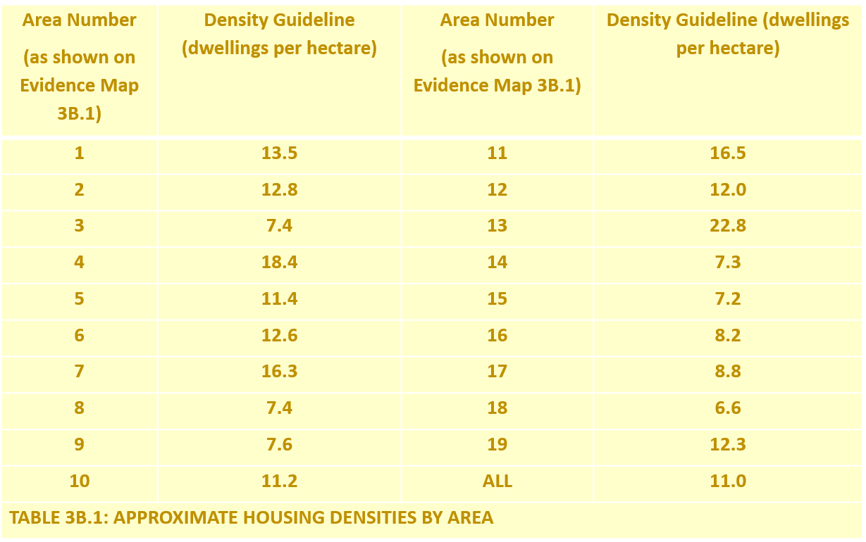
POLICY 3B: DENSITY OF RESIDENTIAL DEVELOPMENTS
P3B.1 The density of new residential developments shall maintain the prevailing character and setting of Saham Toney. To be supported, residential development proposals must shall be guided by the data on existing densities as provided for the 19 areas listed below in Table 3B.1 below.  

Picture
policy 3c: site access and on-site streets layout
​P3C.1 Successful site access and on-site street layout will be promoted by applying the following principles to all development:
  1. Site access shall be compatible with and link successfully with the local road network, shall not impact on highway safety and shall be in full compliance with Local Highway Authority requirements;
  2. Traffic generated by the development shall not have an unacceptable impact on highway safety and proposals which lead to severe residual cumulative impacts on the road network will not be supported;
  3. Streets within a development shall be set out in a way that encourages low vehicle speeds, with traffic calming measures incorporated where necessary to achieve this;
  4. Where appropriate to the size of a development, and practical, there should be more than one pedestrian and vehicular access into and out of a site; and
  5. Where appropriate, pavements shall be provided alongside site roads and shall be wide enough to allow safe passage of pedestrians without recourse to use of the roadway.
policy 3d: parking
​P3D.1 Appropriate provision for parking of vehicles and bicycles site access will be promoted by applying the following principles to all development:
  1. Adequate and safe parking shall be provided for all developments, appropriate to their use.
  2. On-plot parking is preferred for residential developments.
  3. Off-plot parking, if provided, should be in view of the property it serves;
  4. Where on-street parking is provided, it shall preferably take the form of discrete parking bays adjacent to and parallel with the street. Each cluster of parking bays should be designed for no more than 4 or 5 vehicles;  
  5. Secure and convenient cycle storage shall be provided of a quantity consistent with the number of dwellings / bedrooms to promote increased cycle usage;
  6. Developments shall not result in reduced off-plot parking provision for existing properties;
  7. The design and layout shall provide adequate parking space consistent with the anticipated use of the site and taking into account likely resident /user needs, and the parking standards defined in the Local Plan;
  8. Sufficient unallocated parking spaces shall be provided to cater for visitors;
  9. Where parking provision is made to the front of a property, its impact on the street scene shall be softened and mitigated by appropriate and sympathetic boundary treatment;
  10. An appropriate form and amount of parking for disabled people shall be incorporated in accordance with the guidance given in Appendix 2 of the Local Plan;
  11. Residents' parking courts shall not be used other than in exceptional circumstances. Should a parking court form part of the design, it shall not be of a size that dominates the site, and should ideally be visible from the properties they serve.
policy 3e: dark skies preservation
P3E.1 Street lighting of new developments or any other lighting that affects the "dark skies" of the Neighbourhood Area shall normally be avoided. Where street lighting is proposed:
  1. Valid reasons justifying the installation of such lighting shall be provided;
  2. Light spillage from the site shall be avoided;
  3. It shall not be obtrusive;
  4. Proposals shall not materially alter light levels outside the development and/or have the potential to adversely affect the use or enjoyment of nearby buildings or open spaces; and
  5. Lighting proposals shall avoid potentially high impact on wildlife when proposed close to sensitive wildlife receptors or areas
policy 4: non-residential development
​P4.1 Development or enhancement of existing or new business, recreational, sport or tourism related facilities, or new community facilities will be supported where:
  1. It recognises and protects the intrinsic character and beauty of the countryside in line with national policy;
  2. It is of an appropriate scale and sited, designed and landscaped to be sympathetic to its landscape setting and the character and appearance of any neighbouring residential properties;
  3. It would not have a materially adverse impact on the amenities of nearby residential properties or the rural environment in terms of its scale and visual appearance, or any noise, effluent or fumes it would emit;
  4. It would not give rise to a significant increase of road traffic;
  5. Safe and suitable access to the site can be achieved for all people; and
  6. An appropriate level of infrastructure is in place to serve the development.
P4.2 Proposals, including change of use (outside permitted development rights), which result in the loss of the local sport or other recreational facilities will be subject to the same criteria Local Plan Policy COM 04 specifies for community facilities.
P4.3 Proposals where new development increases the demand for sport or other recreational facilities will be subject to the same criteria Local Plan Policy COM 04 specifies for community facilities, in accordance with the requirements of regulation 122 of the Community Infrastructure Levy Regulations 2010.
P4.4 Particular support shall be given to development proposals which provide for:
  1. Start-up businesses by enabling low cost facilities in cooperative clusters;
  2. Businesses to operate from integrated home/work locations;
  3. Extensions and small outbuildings that facilitate working from home;
  4. Enabling micro-businesses (i.e. those that employ fewer than 10 people have a turnover no more than £632,000 [ONS, HMRC & Companies Houses definition]).
policy 5: saham toney rural gap
P5.1 A Rural Gap maintaining separation of Saham Toney from Watton is designated as shown on Policy Map 5.1.
P5.2 Proposals for essential utility infrastructure will be permitted in the rural gap.
P5.3 Otherwise, in the rural gap, development will only be permitted where it is demonstrated in a Design and Access Statement and a Landscape Visual Impact Appraisal that it:
  1. Respects and retains the open and undeveloped nature of the physical and visual gap between Saham Toney and Watton;
  2. Prevents the coalescence of Saham Toney and Watton, and retains the former's separate and distinct character;
  3. Would not affect the rural setting of Saham Toney; and
  4. Recognises the intrinsic and specific landscape value and sensitivity of the countryside in the rural gap, and would enhance the landscape.
policy 6: heritage assets
​P6.1 The parish’s designated heritage assets and their setting including listed buildings, scheduled monuments and designated assets above and below ground, will be conserved or where possible enhanced. Proposals for their development will take into account their significance and contribution to local distinctiveness, character and sense of place.
P6.2 Decisions about proposed changes that could affect the significance of any designated heritage assets shall be made having regard to the advice in the most up to date version of Historic England's Good Practice Advice in Planning: 2 "Managing Significance in Decision-Taking in the Historic Environment", or any more up to date guidance made available by Historic England on its website or elsewhere, and also taking into account the relevant policies in the most up to date version of the National Planning Policy Framework.
P6.3 Proposals for development that affect non-designated heritage assets will be considered taking account of the scale of any harm or loss and the significance of the non-designated heritage assets as set out in the National Planning Policy Framework and as described in a Design and Access Statement or Heritage Statement. In making a balanced judgement between significance and harm, particular attention shall be given to opportunities to conserve, and wherever possible enhance the character, appearance and setting of the non-designated asset. Managed, sympathetic change will be supported.
P6.4 Where a proposed development site includes the location of a Site or Find defined as a designated or non-designated heritage asset in the Saham Toney Heritage Asset Register, or if a new archaeological asset is found during any preliminary site investigations, or has the potential to include heritage assets with archaeological interest, it should ideally be left in situ and undisturbed by the development. If this is not feasible, applicants shall:
  1. Contact Norfolk County Council Environment Service Historic Environment Strategy and Advice team (hep@norfolk.gov.uk) for advice to identify archaeological implications; and
  2. Submit a desk-based study which explains the significance of the asset(s) concerned, and identifies what further measures if any should be taken.
Should it be identified as necessary by preliminary assessment, a field evaluation and satisfactory recording shall be carried out and an archaeological assessment shall be provided that is appropriate to the significance of the asset(s).
Where it is deemed an asset, or assets have significant archaeological interest, conservation or mitigation measures shall be adopted, based on a balanced judgement of their benefit against the likely impact on the development. 
P6.5 Where a need for field evaluation is identified by Breckland Council, a planning condition shall be agreed to prevent any disturbance of the development site until such investigation has been completed to the satisfaction of the Local Planning Authority Archaeologist.
P6.6 For all heritage assets, both designated and undesignated, the level of work required to understand and assess an asset's significance shall be appropriate and proportionate in scope and depth to the importance of the heritage asset potentially affected.
P6.7 For all heritage assets, both designated and undesignated, if some negative impact or loss of fabric is unavoidable, then the applicant will be required to record and advance understanding of the significance of elements, including archaeological deposits, that will be removed or altered, both prior to and during the work.
policy 7a: landscape character preservation & enhancement
P7A.1 All development proposals shall seek to preserve and enhance landscape features which contribute towards local distinctiveness and sense of place.
P7A.2 In general development proposals will be supported where:
  1. Their scale, location and design are appropriate to the landscape character and sensitivity of the area in which they are located;
  2. They will not have an adverse impact on the key natural, built or historic features of an area's landscape character or the overall composition or quality of the landscape character, particularly if the landscape is currently largely unspoiled by obtrusive or discordant features; and
  3. When considered with other recent developments, they do not have an adverse cumulative impact on the local landscape character; and
  4. It retains rural spaces between existing village settlement clusters to avoid their coalescence.
P7A.3 The preservation and where possible enhancement of landscape shall be achieved by recognising and respecting the landscape sensitivity and characteristics of the character area in which a development proposal is located. Landscape character areas are defined and described in the Saham Toney Parish Landscape Assessment, January 2019 and include:
  1. Rural character areas: see Policy Map 7A.1;
  2. Village character areas: see Policy Map 7A.2; and
  3. Settlement fringe areas: see Policy Map 7A.3.
Village Character Areas
P7A.4 Within the settlement boundary, proposals shall respect or reinforce the distinguishing landscape and townscape features in the village character area in which a proposed site is located.
Settlement Fringe Areas
P7A.5 Proposals in the settlement fringe shall:
  1. Avoid hard edges directly onto open countryside and otherwise integrate sensitively to their open setting;
  2. Respect, preserve and where possible, enhance and reinforce the distinguishing landscape features of the rural character area and settlement fringe area in which a proposed site is located (as described in the Saham Toney Parish Landscape Character Assessment 2019); and
  3. Recognise and respect the combined landscape and visual sensitivity of the settlement fringe area in which a site is located as set out in table P7A.1: Settlement Fringe Landscape Sensitivities by Area.
P7A.6 All proposals for sites located in areas of high or moderate-high combined landscape sensitivity, shall include a professionally prepared and proportionate Landscape and Visual Appraisal that provides full justification for the proposal in landscape and visual amenity terms, shows how the area's special landscape qualities will be preserved, and where possible enhanced, and sets out measures that will be taken to mitigate landscape impact. In such areas changes that would degrade the area's combined landscape sensitivity will not be supported.
Rural Character Areas
P7A.7 Proposals beyond the settlement fringes shall be restricted to appropriate countryside development and shall respect and reinforce the distinguishing characteristics of the rural character area (as described in the Saham Toney Parish Landscape Character Assessment 2019) in which a proposed site is located.
P7A.8 Where appropriate development does come forward outside the settlement boundary, opportunities will be sought to address the opportunity and management aims (as set out in the Saham Toney Parish Landscape Character Assessment 2019), for the rural / fringe character area in which a proposed site is located.
Table P7A.1: Settlement fringe landscape sensitivities by area:
​

Picture
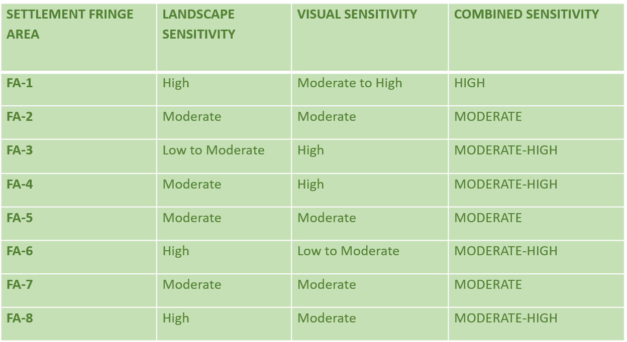
policy 7b: key views
P7B.1 Development proposals shall seek opportunities to preserve, incorporate and where possible enhance the Key Views listed below and shown on Policy Map 7B, and their landscape setting. Development proposals which adversely impact on these key views will not be supported.
  1. Key View 1: West to Saham Hall parkland;
  2. Key View 2: East along Richmond Road to St. George's Church;
  3. Key View 3: South from Hills Road to St. George's Church;
  4. Key View 4: South from Pound Hill across open land towards Saham Mere;
  5. Key View 5: South along Pound Hill to St. George's Church, including the tree canopies that frame this view;
  6. Key View 6: North along Richmond Road to St. George's Church;
  7. Key View 7: South across Broom Hall meadows, including the tree cover in the valley bottom;
  8. Key View 8: North at the Cley Lane village gateway;
  9. Key View 9: West from Ovington Road to Bristow's Mill Tower;
  10. Key View 10: South-west to Threxton Church.
policy 7c: local green spaces
​P7C.1 The open spaces listed below and shown on Policy Maps 7C.1 and &C.2 are designated as Local Green Spaces. New development on these sites will not be permitted other than in exceptional circumstances, which may include essential utility infrastructure for which no other feasible site is available.
ST-GS1: The parish sports field, including the community orchard;
ST-GS2: The Wells Cole Community Centre park land, including the "Growing Together" wildlife area;
ST-GS3: The land immediately surrounding Saham Mere;
ST-GS4: St George's churchyard and cemetery;
ST-GS5: The village allotments;
ST-GS6: The bird sanctuary.
policy 7d: biodiversity & habitats
​P7D.1 Development proposals will be expected to retain existing features of biodiversity value and, where practical to do so, provide a net gain in biodiversity through for example:
  1. The creation of new natural habitats; and
  2. The use of wildlife-friendly features;
P7D.2 Proposals which result in a net loss of biodiversity will not normally be permitted. Development that is likely to have either a direct or indirect adverse impact upon areas of significant biodiversity importance should demonstrate that appropriate mitigation and/or compensation could be provided and where possible achieve a net enhancement to the biodiversity within the area.
P7D.3 Proposals that may adversely affect primary habitats (as defined on Policy Maps 7D.1a/b) or priority habitats (as defined on Policy Maps 7D.2a/b), or the ecological connectivities between them (as defined on Policy Maps 7D.3a/b), or protected species, or other priority species (as defined on Policy Maps 7D.4a/b) shall demonstrate in an ecological assessment, that:
  1. They would contribute to, rather than detract from their biodiversity value; and
  2. They would not sever or destroy the operation of a significant wildlife habitat or its ecological connectivity; or if that is not possible:
  1. They include measures to avoid harm to a significant wildlife habitat or its ecological connectivity; or if that is not possible
  2. Suitable mitigation measures are proposed to reduce or minimise impact on the significant wildlife habitat or ecological connectivity affected; or if that is not possible
  3. Suitable measures are proposed to compensate for harmful effects.
P7D.4 Proposals that would lead to the enhancement of a significant wildlife habitat or ecological connectivity will be supported.
P7D.5 Wherever else possible, opportunities shall be sought and supported to:
  1. Improve habitats and their networks;
  2. Improve the naturalness of green spaces and access to them; and
  3. Improve connectivity with and between green spaces.
P7D.6 Biodiversity offsetting shall be applied where necessary to ensure no net biodiversity loss after impacts have, as far as possible, been avoided, minimised and biodiversity has been restored on-site.
P7D.7 Existing undeveloped green space, both private and public, should be generally conserved for its visual and biodiversity value.
P7D.8 Development proposals shall take account of Natural England’s Impact Risk Zones to assess any potential impact of a proposal on a Site of Special Scientific Interest.
policy 7e: green infrastructure
​P7E.1 Development proposals will be expected to take every opportunity to conserve green infrastructure features of value and, where practical to do so, provide a net gain in green infrastructure.
P7E.2 Development shall recognise the importance of ecosystem services and promote multi-functional land use and connectivity.
P7E.3 Proposals setting out green infrastructure measures to be incorporated in development shall be included in a Design and Access Statement or Planning Statement.
P7E.4 Soft landscaping shall be used in preference to hard wherever possible.
P7E.5 Wherever possible developments shall incorporate small water bodies.
policy 7f: trees & hedges
​P7F.1 Trees, copses and woodlands of good arboricultural or amenity value shall not be removed as a result of development unless justified by an assessment based on an on-site tree and biodiversity survey that verifies that the poor health and condition of such items warrants their removal.
P7F.2 Proposals that may result in significant harm to, or full or partial removal of ancient woodlands and veteran trees shall be wholly exceptional and only permitted if they have been assessed in accordance with Natural England's "Standing Advice for Ancient Woodland and Veteran Trees" (or any more up to date guidance made available by Natural England), and shown to be justified.
P7F.3 Any Category A or B tree or hedgerow, or any Category C tree or hedgerow that has the growth potential to become Category A or B, lost as a result of development shall be adequately compensated elsewhere within the site, taking into account the size and condition of the lost items. Replanting should comprise species that are characteristic of the area and enhance the landscape. Supplementary planting which strengthens the existing network of hedgerows will also be supported.
P7F.4 New developments shall provide for an appropriate level of new tree and hedge planting, with species that are characteristic of the area. New trees and hedges shall be given adequate room to reach maturity. Where necessary, planning conditions should be sought to secure planting of new trees and hedges.
P7F.5 Appropriate measures shall be taken to protect the roots of all existing trees and hedges that are to be retained on a site during the process of development. All retained trees and hedges that could be adversely affected by development shall be protected as defined in sections 5-7 and Appendix A of British Standard BS5837:2012 “Trees in Relation to Design, Demolition and Construction”.
P7F.6 Development adjacent to ancient woodland or veteran trees shall incorporate buffer zones as laid out in Planning Practice Guidance: “Ancient woodland, ancient trees and veteran trees: protecting them from development”.
policy 8a: surface water management general provisions
​P8A.1 All development proposals shall include a site-specific Surface Water Drainage Strategy. That Strategy, including any necessary flood risk mitigation measures, should be agreed as a condition of the development, before any work commences on the site, and implemented before the new development is connected to the existing drainage system. Development will not be allowed to proceed until this condition has been discharged.
P8A.2 All development proposals coming forward within the areas of high, medium and low risk from surface water flooding as identified by the Environment Agency in its up to date online maps, shall include a site-specific Flood Risk Assessment that gives adequate and appropriate consideration to all sources of flooding and the proposed method of surface water drainage.
P8A.3 All proposals shall have a neutral or positive impact on surface water drainage.
P8A.4 All development proposals shall demonstrate engagement with the relevant agencies and shall seek to incorporate appropriate mitigation measures to manage flood risk and reduce surface water run-off to the development and wider area.
P8A.5 All proposals in areas of high, medium or low risk of surface water flooding, regardless of development size, shall be reviewed by the Lead Local Flood Authority (for the means of surface water disposal) and the Statutory Water Undertaker (where surface water is proposed to be discharged into the public sewerage network) prior to being decided.
P8A.6 Permission for proposals for which no other practicable alternative exists to dispose of surface water other than a public sewer, shall only be granted if it is confirmed by Anglian Water, the Local Highways Authority, or their agents that there is adequate spare capacity in the existing system taking future development requirements into account.
P8A.7 As a condition of their adoption, SuDS drainage schemes shall comply with the guidelines given in Water UK’s "Sewers for Adoption", Edition 8, 2019, or any more up to date version made available, and with the most up to date version of CIRIA 753, The SuDS Manual.
policy 8b: surface water runoff (discharge) rate & volume
​P8B.1 Appropriate on-site water storage measures shall be incorporated in the drainage scheme to intercept, attenuate or store long term surface water run-off within the development site boundary, up to and including the 1% AEP (Annual Exceedance Probability) event plus 40% climate change allowance.
P8B.2 For the 100% AEP and the 1% AEP events, the peak runoff rate and volume from a site to any highway drain, sewer or surface water body:
  1. For greenfield developments, shall never exceed the peak greenfield runoff rates and volumes for the same events;
  2. For brownfield developments, shall be as close as reasonably practical to the greenfield runoff rates and volumes for the same events, but shall never exceed the rates and volumes of discharge from the site for the same event prior to redevelopment.
P8B.3 The method used to calculate pre- and post-development runoff rates and volumes shall be agreed with the Lead Local Flood Authority and stated in the Drainage Strategy.
P8B.4 Where it is not possible to dispose of any runoff additional to greenfield rates and/or volumes on the site, final runoff rates and/or volumes shall be restricted further to ensure compliance with Standard S6 of the SuDS Non-Statutory Technical Standards (2015) or any subsequent update of those standards.
P8B.5 If control to greenfield runoff volume is considered unachievable, then any excess runoff volume shall be temporarily stored and released at a rate no more than 2l/s/ha.
P8B.6 Proposals shall identify appropriate SuDS discharge outlets for surface water runoff (both above and underground).
P8B.7 Where discharge is into an ordinary watercourse with known surface water flooding issues, a flood flow (i.e. surcharged outfall) shall be applied as a constraint in runoff calculations., using the 1% AEP event, plus relevant catchment specific, climate change fluvial flow.
P8B.8 Drainage strategies shall consider and account for the potential increase in the volume of runoff from a development as a result of increases in the area of impermeable surfaces.
P8B.9 Where runoff from off-site sources is drained together with the site runoff, the contributing catchment shall be modelled as part of the drainage system in order to take full account of the additional inflows to the site.
P8B.10 Where runoff from off-site sources is conveyed separately to a site’s proposed drainage system the flood risk should be managed in accordance with BS8533:2011 “Assessing and managing flood risk in development – code of practice”.
P8B.11 Surface water run-off mitigation measures shall address any identified risk of flooding in the Lead Local Flood Authority’s order of priority: Assess; Avoid; Manage and Mitigate.
P8B.12 For residential developments, an allowance based on development density for increases in impermeable surfaces throughout the lifetime of a development shall be considered in runoff calculations, up to total impermeable surface percentage of 100%. The allowance shall be:
  1. 10%, where density is less than or equal to 25 dwellings per hectare;
  2. 8%, where density is greater than 25, but less than or equal to 30 dwellings per hectare;
  3. 6%, where density is greater than 30, but less than or equal to 35 dwellings per hectare;
  4. 4%, where density is greater than 35, but less than or equal to 45 dwellings per hectare;
  5. 2%, where density is greater than 45 dwellings per hectare.
policy 8c: infiltration testing
​P8C.1 All proposals shall include an assessment of the suitability of the underlying geology to discharge collected surface water to the ground via infiltration.
P8C.2 Evidence from infiltration tests shall be submitted to support the assumed infiltration rate(s) across a site.
P8C.3 Infiltration testing shall be undertaken in line with BRE Digest 365 guidance, and shall include a minimum of three tests undertaken within 24 hours at each location.
P8C.4 The depth of testing shall be representative of the drainage proposals.
P8C.5 It shall be confirmed that any proposed use of infiltration will not lead to any geotechnical risks to a site.
P8C.6 On-site test results shall be made submitted at appropriate planning application stages in accordance with the recommendations of CIRIA C753: The SuDS Manual.
policy 8d: surface water flood risk & climate change
​P8D.1 Assessment of flood risk and design of a surface water drainage system shall include allowance for climate change in accordance with the most up to date Government guidance.
P8D.2 For sustainable drainage systems, a 40% climate change scenario shall be tested for developments with a lifespan over 50 years.
P8D.3 Peak river flow climate change allowances for the relevant catchment (in line with Environment Agency guidance “Flood Risk Assessments: Climate Change Allowances’, shall be considered for ordinary watercourses as well as main rivers.
policy 8e: surface water drainage & water quality
​P8E.1 All proposals shall consider risk to water quality that may arise, taking account of the final discharge location(s).
P8E.2 Where piped components are proposed as part of a surface water drainage scheme, non-piped SuDS components shall be used to treat water prior to final discharge.
P8E.3 Providing it is separated from other surface water runoff residential roof water may be directly discharged to a watercourse or soakaway without treatment.
P8E.4 The sensitivity of the receiving waterbody (ground or surface), including protected aquifers, should be considered and extra water quality treatment provided if a protected resource is identified.
P8E.5 Protection of water quality in the Breckland SAC and Norfolk SAC shall be given high priority.
P8E.6 Proposals shall demonstrate a total pollution mitigation index ≥ the pollution hazard index, using the indices set out in chapter 26 of CIRIA 753: The SuDS Manual, or by a bespoke risk assessment process.
policy 8f: management & maintenance of sustainable drainage systems
​P8F.1 All proposals shall appropriately address the management and maintenance of SuDS to account for the construction and long-term operation of all components of the drainage system, both surface and sub-surface.
P8F.2 Proposals shall sufficiently consider the likely maintenance requirements of new and existing drainage infrastructure over the design life of a development, including those for ordinary watercourses that are bounded by, or within a development site.
P8F.3 All proposals shall provide a SuDS Management and Maintenance Plan including:
  1. A maintenance schedule of work detailing the activities required and who will adopt and maintain the surface water drainage features for the lifetime of the development; and
  2. Clear maintenance and management proposals for SuDS elements, including riparian ownership of ordinary watercourses or culverts, and their associated funding mechanisms.
P8F.4 Where SuDS is not proposed to be adopted by the Local Highways Authority or Anglian Water, maintenance plans and schedules shall be included with a proposal, clearly communicating requirements on any future property owners, in accordance with section 12 and 11.4 of British Standard BS8582:2013. Such communication shall include explanation of the consequences of future property owners not carrying out the maintenance.
P8F.5 Appropriate easements shall be provided around SuDS features to allow access for maintenance.
P8F.6 Where pumping is proposed as part of SuDS, it shall be demonstrated that appropriate maintenance proposals are included for the pumping system.
P8F.7 All SuDS management and maintenance proposals shall be guided by the most up to date version of CIRIA 753: The SuDS Manual.
policy 8g: resistance & resilience of sustainable drainage systems
​P8G.1 SuDS capacity shall be such that no onsite flooding or increased offsite flood risk will occur for events up to the drainage system standard of service capacity, which shall be taken as the 1% AEP plus climate change allowance. All proposals shall demonstrate how impacts to people and property will be minimised where this is a residual risk of flooding (i.e. if the drainage system capacity will be exceeded in an event greater than the 1% AEP event plus 40% climate change).
P8G.2 All proposals shall demonstrate that safe access and egress through a site will be maintained during a flood event that exceeds the 1% AEP plus 40% climate change.
P8G.3 It shall be demonstrated that the drainage system is designed so that unless specifically designated to hold or convey water, flooding will not occur in any part of a building nor to utility plant that is susceptible to water.
P8G.4 Where applicable, proposals shall identify safe exceedance routes and storage areas for residual flood water.
P8G.5 In all cases there shall be a minimum of at least 150mm freeboard between proposed external ground levels and property finished ground floor levels (FFL).
P8G.6 Resistance and resilience measures shall be included where there is a residual risk of flooding. In such cases, as a minimum, property FFL throughout the development shall be set to a minimum of 300mm freeboard above the anticipated flood levels in a 1% AEP event plus 40% climate change from any source of flooding. This shall be increased to 600mm where there is uncertainty about flood levels.
P8G.7 The design of the drainage system for exceedance flow management shall take account of any residual flood risk for the site. An assessment shall also be made of the likely significance of risks associated with the following scenarios:
  1. A blockage or failure of a drainage system component;
  2. Failure of any embanked storage facility; and
  3. Rainfall events that are larger than the storms used for the design of the drainage system.
P8G.8 Where there is a residual risk of flooding, design shall be such that water on roads where speed limits do not exceed 30mph shall be no greater than 100 mm deep where there are kerb upstands.
P8G.9 All proposals shall demonstrate the use of appropriately flood resistant / resilient construction.
policy 8h: design of sustainable drainage systems
​P8H.1 Surface water runoff shall be controlled as near its source as possible through a sustainable drainage approach.
P8H.2 The provision of a sustainable urban drainage system (SuDS) is the preferred method to manage surface water runoff, and the proposed method of draining a site shall be in accordance with the sustainable drainage hierarchy.
P8H.3 All necessary SuDS design data and calculations shall be presented with proposals and shall demonstrate the system will function satisfactorily throughout its lifetime.
P8H.4 Where a SuDS solution is proposed, outline or final SuDS Design Statements shall be provided at appropriate stages of a planning application.
P8H.5 Design of the proposed drainage system shall be such that runoff is completely contained within the system for all events up to the standard of service for the critical duration event for the system (the 1% AEP, 6-hour plus allowance for climate change event).
P8H.6 All drainage system proposals shall be guided by the drainage section of the most up to date version of the Saham Toney Parish Design Guide and the most up to date version of CIRIA Report C753: The SuDS Manual.
P8H.7 Infiltration drainage shall generally be shallow (less than 2m deep); deeper methods shall only be used in exceptional circumstances.
P8H.8 A design safety factor shall be applied to measured infiltration rates, guided by Table 25.2 of CIRIA Report C753: The SuDS Manual.
P8H.9 Where the rate of infiltration established in accordance with Policy 8C is found to be less than 1 x 10⁻⁶ m/s or 0.0036 m/hour, only partial or no infiltration should be considered at a site, combined with on-site interception of run-off.
P8H.10 Design shall demonstrate sufficient surface water storage capacity to enable an infiltration system to meet the design standard of service.
P8H.11 Where any part of the system is at risk of inundation during extreme events, the impact of a potential loss of storage on overall system performance shall be evaluated and accounted for.
P8H.12 SuDS features shall be provided with appropriate inlets, outlets and control components to manage the flow of water. Such components shall be resistant to blockage.
P8H.13 There shall be a minimum of 1.0m between the base of any soakaway and seasonally high groundwater levels.
P8H.14 Wherever possible and practical, drainage system design proposals shall take every opportunity to improve (i.e. lessen) existing flood risk on a site and/or in downstream areas.
P8H.15 Where applicable, design of SuDS systems shall include measures to improve land drainage via watercourses or ditches that form part of a site or run adjacent to its boundary, and make adequate provision for their future maintenance.
P8H.16 Culverting of existing watercourses shall be avoided wherever possible. If adopted, it shall be in accordance with the Lead Local Flood Authority’s Standing Advice 1: Ordinary Watercourse Consenting.
P8H.17 Design of temporary drainage for the construction phase shall be included where necessary and shall demonstrate construction activities will not lead to an increase in flood risk.
P8H.18 SuDS design shall meet the most up to adoption standards of the Highways Authority and/or Anglian Water as applicable.
policy 9: sewerage provision
​P9.1 All new development will be expected to connect to the public foul sewerage network in accordance with the requirements of Anglian Water unless evidence is produced that it is not feasible to do so.
P9.2 Evidence shall be provided by applicants to demonstrate that capacity* is available within the foul sewerage network, including at the treatment works and at intermediate pumping stations, or can be made available in time to serve the development.
P9.3 If mains sewerage is demonstrably not feasible then an effective and sustainable private sewerage system plan shall be agreed with the Local Planning Authority in advance of development commencing. Such a plan must be implemented prior to the occupation of the first dwelling.
P9.4 All development proposals for 10 or more houses shall include a sewerage capacity assessment. Where such assessment identifies a need for mitigation within the foul sewer network any foul drainage solution must be implemented before occupation commences.
P9.5 All development proposals shall demonstrate that there is no increased risk of flooding either on the development site itself or to the wider area from sewers or artificial sources as a result of the development.
P9.6 Foul sewers shall comply with the guidelines given in "Sewers for Adoption", Edition 8, 2019, or any more up to date version made available.
*When calculating available capacity, the nominal diameter of foul sewer pipes shall be reduced by 20% to account for potential surface water flows into foul sewers.

GROWTH & DEVELOPMENT POLICY MAPS
policy_map_2a_allocated_sites.pdf
File Size: 1402 kb
File Type: pdf
Download File

policy_maps_2f.1-9_indicative_site_access_plans.pdf
File Size: 1088 kb
File Type: pdf
Download File

policy_map_2g.1_masterplanning_stnp1_4___7.pdf
File Size: 466 kb
File Type: pdf
Download File

policy_map_2g.2_masterplanning_stnp16.pdf
File Size: 495 kb
File Type: pdf
Download File

policy_map_2h_stnp1_site_location_plan.pdf
File Size: 116 kb
File Type: pdf
Download File

policy_map_2i_stnp2_site_location_plan.pdf
File Size: 84 kb
File Type: pdf
Download File

policy_map_2j_stnp4_site_location_plan.pdf
File Size: 111 kb
File Type: pdf
Download File

policy_map_2k_stnp7_site_location_plan.pdf
File Size: 105 kb
File Type: pdf
Download File

policy_map_2l_stnp9_site_location_plan.pdf
File Size: 95 kb
File Type: pdf
Download File

policy_map_2m_stnp13_site_location_plan.pdf
File Size: 100 kb
File Type: pdf
Download File

policy_map_2n_stnp14_site_location_plan.pdf
File Size: 144 kb
File Type: pdf
Download File

policy_map_2o_stnp15_site_location_plan.pdf
File Size: 102 kb
File Type: pdf
Download File

policy_map_2p_stnp16_site_location_plan.pdf
File Size: 163 kb
File Type: pdf
Download File

ENVIRONMENTAL PROTECTION POLICY MAPS
policy_map_5_saham_toney_rural_gap.pdf
File Size: 556 kb
File Type: pdf
Download File

policy_map_6a_saham_toney_heritage_assets_-_buildings__north_.pdf
File Size: 646 kb
File Type: pdf
Download File

policy_map_6b_saham_toney_heritage_assets_-_buildings__south_.pdf
File Size: 873 kb
File Type: pdf
Download File

policy_map_6c_saham_toney_heritage_assets_-_sites___finds__north_.pdf
File Size: 676 kb
File Type: pdf
Download File

policy_map_6d_saham_toney_heritage_assets_-_sites___finds__south_.pdf
File Size: 641 kb
File Type: pdf
Download File

policy_maps_7a.1-3_landscape_character_areas.pdf
File Size: 912 kb
File Type: pdf
Download File

policy_map_7b_key_views.pdf
File Size: 297 kb
File Type: pdf
Download File

policy_map_7c_local_green_spaces.pdf
File Size: 354 kb
File Type: pdf
Download File

policy_map_7d.1a_primary_habitats__north_.pdf
File Size: 652 kb
File Type: pdf
Download File

policy_map_7d.1b_primary_habitats__south_.pdf
File Size: 704 kb
File Type: pdf
Download File

policy_map_7d.2a_priority_habitats__north_.pdf
File Size: 501 kb
File Type: pdf
Download File

policy_map_7d.2b_priority_habitats__south_.pdf
File Size: 689 kb
File Type: pdf
Download File

policy_map_7d.3a_ecological_connectivity__north_.pdf
File Size: 539 kb
File Type: pdf
Download File

policy_map_7d.3b_ecological_connectivity__south_.pdf
File Size: 793 kb
File Type: pdf
Download File

policy_map_7d.4a_priority_species_sightings__north_.pdf
File Size: 497 kb
File Type: pdf
Download File

policy_map_7d.4b_priority_species_sightings__south_.pdf
File Size: 681 kb
File Type: pdf
Download File

Site prepared & maintained by the Saham Toney Neighbourhood Plan work group
  • Home
    • Welcome Message
    • About us & Contacts
    • What's it all about? >
      • Q&A
      • Why Have a Neighbourhood Plan
    • What Do You Think of This Website?
    • Data Protection & OS License
    • Files For Printing
  • Aims
    • Sustainable & Balanced Development
  • Timeline
  • Village Info
    • Saham Toney in Numbers
    • Village Heritage >
      • How Saham Has Been Shaped Through History
      • Saham Toney Heritage Group
    • Planning Issues in Saham Toney
    • Parish Action Points
    • Village quiz
  • SEA & HRA
    • SEA & HRA Screenings
    • Draft Reg 14 Plan for HRA and SEA
    • Draft Reg 15 Plan for HRA and SEA
  • Flood Risk
    • Village Flood Event Photos & Videos
    • Flood Risk Guides
  • Consultations
    • Regulation 16 Consultation on the Plan
    • Regulation 15 Submission of the Plan
    • Regulation 14 (3) Consultation June 2020 >
      • 2020 Reg. 14 Consultation Results
      • Regulation 14 (3) Consultation Documents
      • Reg 14 (3) Consultation Announcement June 2020
      • Online Consultation 'drop-in' sessions
    • SEA Consultation June-July 2020
    • Regulation 14 Consultation 2019 >
      • 2018 Regulation 14 Consultation Results
    • What You Told Us Earlier
    • Awareness & Housing Questionnaire
  • Site Allocations
    • Site Selection Process
    • AECOM Site Assessment Report
    • Site Selection Report
    • Site Allocations Event 14 July 2019
    • Site Allocations Background
    • Master Planning Information
  • Funding & Costs
  • OUR CONSULTANTS
  • Referendum
    • Our Referendum Campaign >
      • "Vote Yes!" Campaign Videos
  • Examination
    • Examination Documents >
      • Summary of the examination results
      • Public Hearing 17 February 2021
  • Publicity
    • Plan Information Leaflet & Pamphlet June 2020
    • Radio Norfolk Interview 6 Nov 2021
    • Saham Saga Articles
    • Stay at Home Slideshows May 2020
    • Village Presentation 7th December 2018
    • Village Presentation 14th August 2018
    • Village Presentation 14 December 2017
    • Parliamentary Debate on Neighbourhood Planning
    • Parliamentary Debate on 5 Year Land Supply
  • Planning Applications
    • Guidelines for Commenting on Planning Applications >
      • How to Seach Breckland Council's Site for Planning Applications
      • Relevant Policies That May Apply to an Application
  • Reg's & References
    • Guides on Neighbourhood Planning
    • Stages of a Plan
  • Archive
    • Archived Reg 14 & 15 Documents >
      • Regulation 15 Submission Documents
      • Reg 15 Policies & Policy Maps
      • Reg 14 (3) Policies & Policy Maps
      • 2019 Regulation 14 Consultation Documents
      • Policy Maps REG 14 (2) Aug 2020
      • Reg 15 Policies & Policy Maps