
THE NEIGHBOURHOOD PLAN & FLOOD RISK
Parts of Saham Toney regularly suffer from surface water flooding. This occurs principally along the flow paths shown on the watercourse map given further down this page, which was prepared by the Lead Local Flood Authority (taken from Norfolk County Council’s Flood Investigation Report for Watton and the surrounding area on 23 June 2016) Photos and videos of village flood events can be found HERE If you have any more we can add please email them to us at stnp2036@gmail.com |
Watch a short animation about SuDS (sustainable drainage systems)
Copyright: Susdrain What can villagers do to help themselves?
You can download various guides HERE |
Proposals to alleviate flood risk
In conjunction with 2 villagers, in the autumn of 2020 we put forward ideas for the creation of flood attenuation basins to reduce flood risk to properties further downstream. the ideas were further developed and engineered by the LLFA who implemented the proposals in September 2021. You can find the proposals below
In conjunction with 2 villagers, in the autumn of 2020 we put forward ideas for the creation of flood attenuation basins to reduce flood risk to properties further downstream. the ideas were further developed and engineered by the LLFA who implemented the proposals in September 2021. You can find the proposals below
|
Photos of the implemented measures will be added when available
| ||
VILLAGE FLOODING DECEMBER 2020
We greatly sympathise those villagers who again suffered flooding following the prolonged rain during the week before Christmas. Among those were several residents of Cley Lane, who contacted one of our group, who as a result sent a letter to the powers that be, re-emphasising the problems and asking for action to be taken. You can read that letter below (in which some personal information has been redacted) :
We greatly sympathise those villagers who again suffered flooding following the prolonged rain during the week before Christmas. Among those were several residents of Cley Lane, who contacted one of our group, who as a result sent a letter to the powers that be, re-emphasising the problems and asking for action to be taken. You can read that letter below (in which some personal information has been redacted) :
| letter_re_dec_2020_flooding__t_bunce_29dec2020__redacted_.pdf |
Both our District Councillor and MP responded proactively to the letter. Councillor Ed Connolly liaised both with villagers and the Lead Local Flood Authority, and George Freeman MP's reply setting out what he planned to do, is given below:
| g_freeman_flood_issues_response_09jan2021__case_ref__za33360_.pdf |
Here is the response George Freeman MP received from Norfolk County Council when he took up village problems with the County:
| ncc_response_to_g_freeman_re_flooding_20jan2021_response_enq_452467.pdf |
In the light of the latest problems, it's a good time to clarify again that the Plan can and does include a policy to ensure new developments will not add to flood risk, and includes measures for certain allocated sites that should have the added benefit of reducing risk elsewhere. But that is only part of the problem, and it is important to stress that unfortunately the Plan itself cannot tackle existing problems unrelated to new development.
In addition we have published a village SuDS Design Manual, which gives a lot of detailed information and guidance about how to design satisfactory and effective surface water drainage schemes
In addition we have published a village SuDS Design Manual, which gives a lot of detailed information and guidance about how to design satisfactory and effective surface water drainage schemes
FLOOD RISK IN SAHAM TONEY
Saham Toney Watercourse (courtesy of the Norfolk County Council Lead Local Flood Authority):
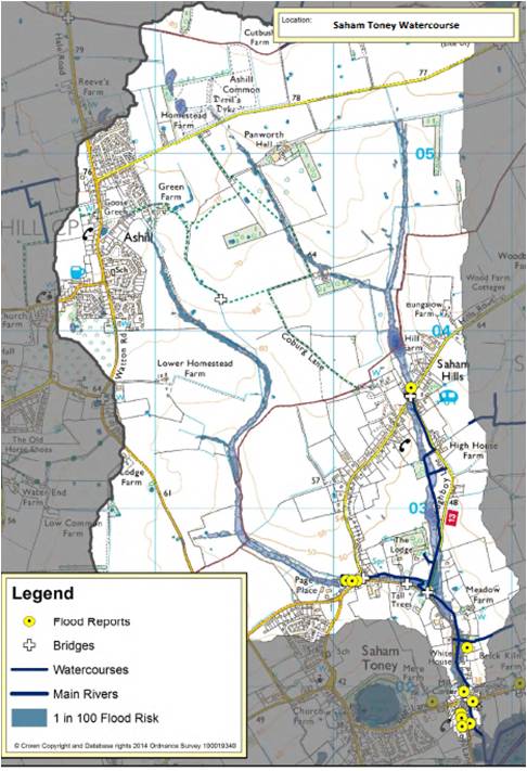
The surface water that flows through Saham Toney and Saham Hills originates north of the Parish in the Ashill area. The main parts of the village affected are along Pages’s Lane, Chequers Lane, Bell Lane and Ploughboy Lane.
Can the Plan prevent future floods? In general, unfortunately, in a word, NO
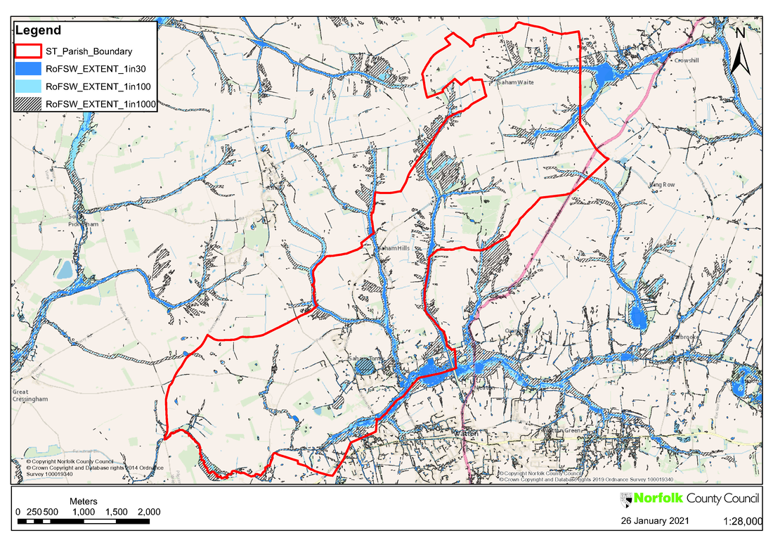
The Plan cannot solve existing flooding problems, which as illustrated in the map above, sometimes originate in neighbouring parishes. A neighbourhood plan can only deal with the development of land, not the rectification of problems that pre-date such development (except where those problems are on a proposed site itself).
The Plan cannot control Nature, so rainwater will continue to drain via the watercourses shown on the map. In future extreme events, such as the one in June 2016, there is a high likelihood they would again be unable to cope with the volume of water running off the land.
This problem is further exasperated in Saham because groundwater levels are generally high, meaning there is less capacity for water to be held in the ground long enough to prevent overflow of the watercourses and the flooding that consequently occurs.
The Environment Agency publishes an online map that shows areas at high, medium, low and very low risk of surface water flooding, as shown below (the version with the Parish boundary overlay is courtesy Norfolk County Council). You can find the online map, which allows you to zoom in on a particular area, at https://flood-warning-information.service.gov.uk/long-term-flood-risk/
Can the Plan prevent future floods? In general, unfortunately, in a word, NO
The Plan cannot solve existing flooding problems, which as illustrated in the map above, sometimes originate in neighbouring parishes. A neighbourhood plan can only deal with the development of land, not the rectification of problems that pre-date such development (except where those problems are on a proposed site itself).
The Plan cannot control Nature, so rainwater will continue to drain via the watercourses shown on the map. In future extreme events, such as the one in June 2016, there is a high likelihood they would again be unable to cope with the volume of water running off the land.
This problem is further exasperated in Saham because groundwater levels are generally high, meaning there is less capacity for water to be held in the ground long enough to prevent overflow of the watercourses and the flooding that consequently occurs.
The Environment Agency publishes an online map that shows areas at high, medium, low and very low risk of surface water flooding, as shown below (the version with the Parish boundary overlay is courtesy Norfolk County Council). You can find the online map, which allows you to zoom in on a particular area, at https://flood-warning-information.service.gov.uk/long-term-flood-risk/
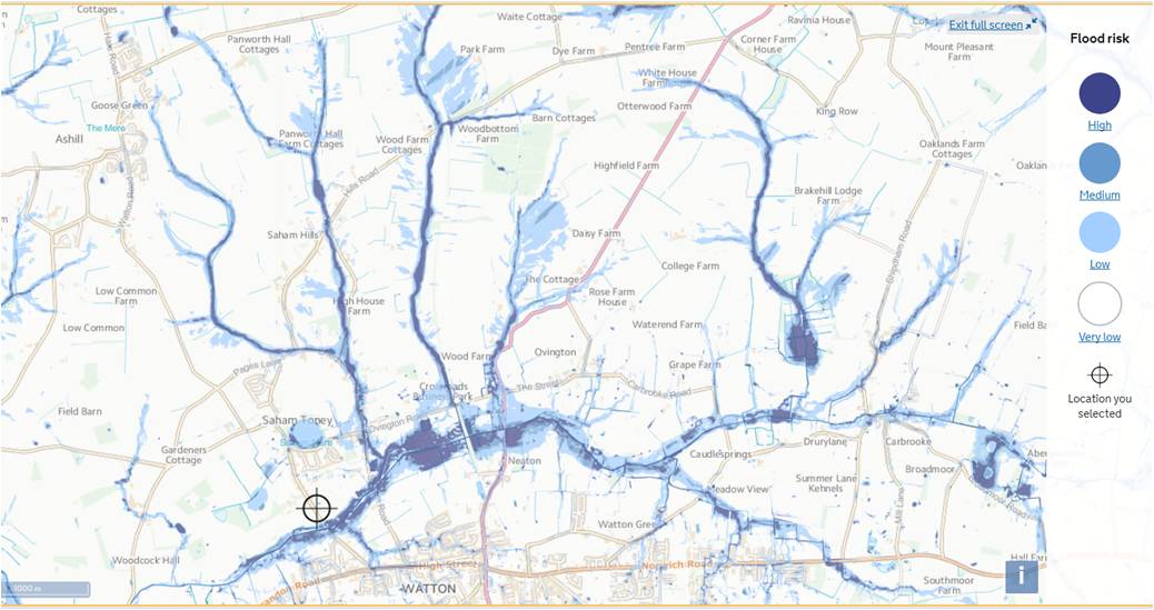
Unsurprisingly, it shows the areas most at risk to be those along the watercourses shown in the first map.
It is important to understand what the Environment Agency means by each level of risk:
High - each year, the area has a chance of flooding of greater than 1 in 30 (3.3%)
Medium - each year, the area has a chance of flooding of between 1 in 100 (1%) and 1 in 30 (3.3%)
Low - each year, the area has a chance of flooding of between 1 in 1000 (0.1%) and 1 in 100 (1%)
Very low - each year, the area has a chance of flooding of less than 1 in 1000 (0.1%)
Why might new development increase flood risk?
If new development, particularly in the areas of greatest risk, happens without adequate control, during heavy rainfall it might increase the rate of surface water run-off to the surrounding area, because permeable ground might be replaced with hard impermeable surfaces. Although the amount of rainfall would not be changed by the development (that’s in Nature’s control), since it would not be able to soak into the ground it could only drain to the nearest permeable ground, or worse, directly from the site onto existing roads or into existing roadside ditches. The situation differs when a brownfield (already developed) site is redeveloped, since it will often already have had impermeable surfaces (concrete hard-standings, for example) that may have increased the rate of surface water run-off for many years.
How do planning rules control flood risk?
The National Planning Policy Framework (NPPF) sets the overall rules for development in England and Wales. In summary it says:
The Breckland Local Plan dictates that all new development:
Can the Neighbourhood Plan prevent increased risk of flooding? YES
When preparing the Neighbourhood Plan, we felt that the national and district planning rules were okay up to a point, but lacked sufficient rigour and clarity, thus leaving loopholes that some developers may (and do) exploit. We wanted to strengthen the good points in the planning rules, and make them more locally specific, while also eliminating loopholes.
How does the Neighbourhood Plan do that?
In Policies 8A-8H and 9, the Plan requires:
Additionally masterplanning for allocated sites STNP 1, 4 and 7 (on Page's Lane, Pound Hill and Chequers Lane includes areas of green space, that while providing a pleasant environment, have a primary function as space for the incorporation of surface water runoff attenuation and mitigation measures.
The Plan's policies have been reviewed by a specialist and concluded to be robust in the way they deal with development and potential flood risk. Those policies have been praised and supported by the Lead Local Flood Authority.
We accept and understand that whatever measures the Plan includes, some people will remain concerned by flood risk, and we take their concerns seriously. We understand and respect the case made that there should be no new development until existing flood problems are solved. In answer to that we say this: the removal of sites from allocation in the Plan would not guarantee those sites would not still be developed; but what it would guarantee is that they would come forward in an ad hoc and less controlled manner, without many of the flood risk controls the Plan imposes on them. That is evidenced by many developments permitted over the last 6-7 years, and the often spurious information presented by their developers to justify being granted permission to build in flood risk zones, while not being held in check by any meaningful policies on the topic
It is important to understand what the Environment Agency means by each level of risk:
High - each year, the area has a chance of flooding of greater than 1 in 30 (3.3%)
Medium - each year, the area has a chance of flooding of between 1 in 100 (1%) and 1 in 30 (3.3%)
Low - each year, the area has a chance of flooding of between 1 in 1000 (0.1%) and 1 in 100 (1%)
Very low - each year, the area has a chance of flooding of less than 1 in 1000 (0.1%)
Why might new development increase flood risk?
If new development, particularly in the areas of greatest risk, happens without adequate control, during heavy rainfall it might increase the rate of surface water run-off to the surrounding area, because permeable ground might be replaced with hard impermeable surfaces. Although the amount of rainfall would not be changed by the development (that’s in Nature’s control), since it would not be able to soak into the ground it could only drain to the nearest permeable ground, or worse, directly from the site onto existing roads or into existing roadside ditches. The situation differs when a brownfield (already developed) site is redeveloped, since it will often already have had impermeable surfaces (concrete hard-standings, for example) that may have increased the rate of surface water run-off for many years.
How do planning rules control flood risk?
The National Planning Policy Framework (NPPF) sets the overall rules for development in England and Wales. In summary it says:
- Avoid inappropriate development in areas at risk of flooding by directing development away from areas at highest risk (whether existing or future). Where development is necessary in such areas, the development should be made safe for its lifetime without increasing flood risk elsewhere.
- Use opportunities provided by new development to reduce the causes and impacts of flooding (where appropriate through the use of natural flood management techniques).
- Ensure that flood risk is not increased elsewhere. Where appropriate, applications should be supported by a site-specific flood-risk assessment.
- Development should only be allowed in areas at risk of flooding where (a) it is appropriately flood resistant and resilient; (b) it incorporates sustainable drainage systems, unless there is clear evidence that this would be inappropriate; and (c) any residual risk can be safely managed.
The Breckland Local Plan dictates that all new development:
- Is located to minimise the risk of flooding, mitigating any such risk through design and implementing sustainable drainage (SuDS) principles.
- Incorporates appropriate surface water drainage mitigation measures to minimise its own risk of flooding and should not materially increase the flood risk to other areas.
- Will not increase green field run off rates and vulnerability of the site, or the wider catchment, to flooding from surface water run-off from existing or predicted water flows;
- Wherever practicable, have a positive impact on the risk of surface water flooding in the surrounding area adjacent to the development.
Can the Neighbourhood Plan prevent increased risk of flooding? YES
When preparing the Neighbourhood Plan, we felt that the national and district planning rules were okay up to a point, but lacked sufficient rigour and clarity, thus leaving loopholes that some developers may (and do) exploit. We wanted to strengthen the good points in the planning rules, and make them more locally specific, while also eliminating loopholes.
How does the Neighbourhood Plan do that?
In Policies 8A-8H and 9, the Plan requires:
- Planning applications for all allocated sites must include site-specific Flood Risk Assessment and / or a Drainage Strategy. This will ensure both we villagers and Breckland’s planners will be able to confirm that adequate flood mitigation measures have been proposed where necessary, and a satisfactory drainage scheme for the site exists before it is approved;
- Any other sites at high, medium or low risk of surface water flooding (as shown on Environment Agency maps) must include a site-specific Flood Risk Assessment and a Drainage Strategy with a planning application. Those documents must prove that there is no increased risk of surface water flooding either on the development site itself or to existing property or infrastructure, nor any risk of ground water flooding on the site or within 1 km of its boundary
- Sites must have on-site water storage to intercept, attenuate or store long-term surface water run-off up to a 100-year flood limit (thus reducing flood risk to no worse than “low” by Environment Agency definition);
- Sites must not increase the surface water runoff rates or volumes that existed prior to development, and where possible should decease them;
- Ditches and watercourses within a site or running along its boundary must be improved;
- All new drainage systems must be managed and maintained over their lifetime;
- Climate change effects (i.e the potential for increased levels of rainfall) must be taken into account;
- Water quality must be safeguarded;
- Applications for all sites in high or medium flood risk areas shall be reviewed by the Lead Local Flood Authority and Anglian Water (neither normally review sites with less than 20 houses); and
- There is adequate capacity in the sewerage system to cope, and calculations to show that include an allowance for surface water entering the foul system (up to 25% of its capacity).
Additionally masterplanning for allocated sites STNP 1, 4 and 7 (on Page's Lane, Pound Hill and Chequers Lane includes areas of green space, that while providing a pleasant environment, have a primary function as space for the incorporation of surface water runoff attenuation and mitigation measures.
The Plan's policies have been reviewed by a specialist and concluded to be robust in the way they deal with development and potential flood risk. Those policies have been praised and supported by the Lead Local Flood Authority.
We accept and understand that whatever measures the Plan includes, some people will remain concerned by flood risk, and we take their concerns seriously. We understand and respect the case made that there should be no new development until existing flood problems are solved. In answer to that we say this: the removal of sites from allocation in the Plan would not guarantee those sites would not still be developed; but what it would guarantee is that they would come forward in an ad hoc and less controlled manner, without many of the flood risk controls the Plan imposes on them. That is evidenced by many developments permitted over the last 6-7 years, and the often spurious information presented by their developers to justify being granted permission to build in flood risk zones, while not being held in check by any meaningful policies on the topic